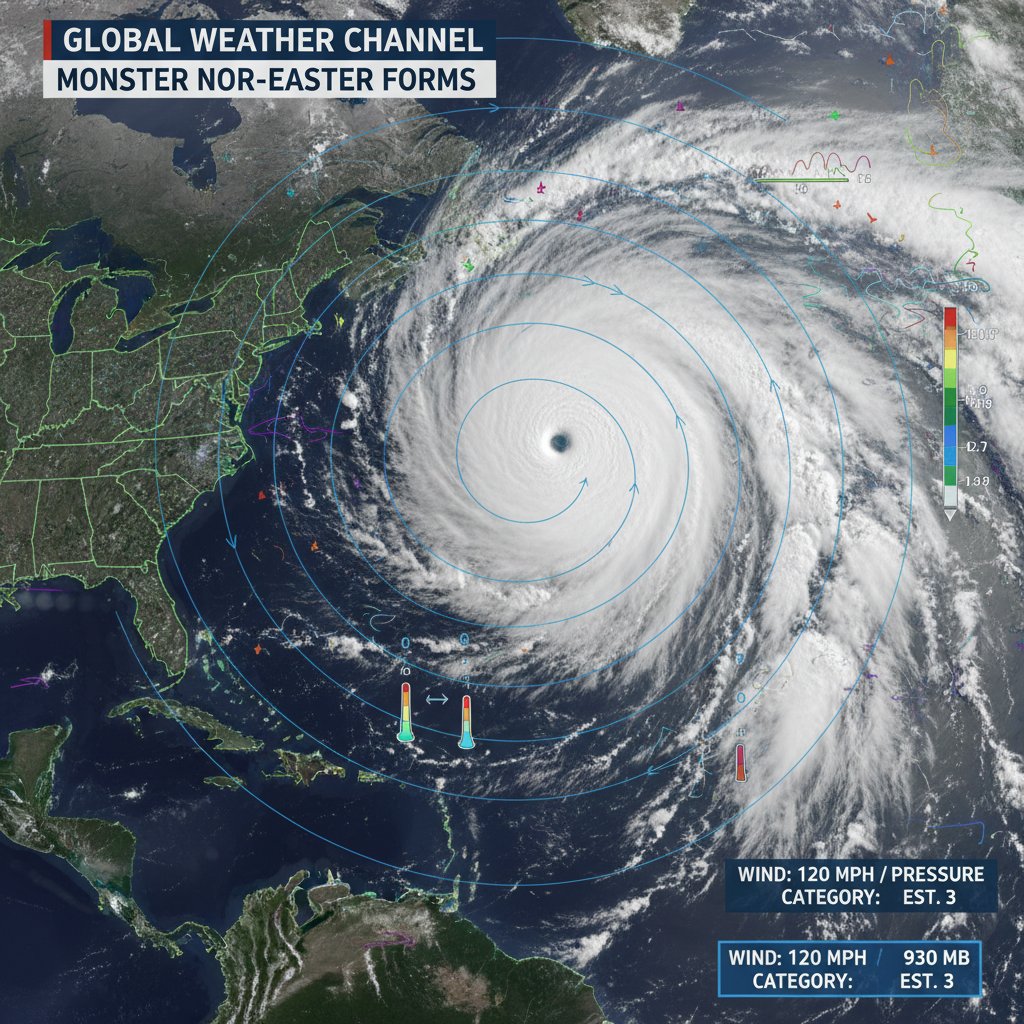
Meteorologists are closely monitoring a rapidly intensifying storm system that is expected to lash the U.S. East Coast starting late Sunday. From Washington, D.C. to Boston, tens of millions of residents are preparing for what could be the most significant winter weather event of the season. National Weather Service (NWS) bulletins issued early Saturday indicate that this nor’easter possesses the potential for "bombogenesis"—a process where atmospheric pressure drops so sharply that the storm takes on the characteristics of a winter hurricane.
The storm is currently coalescing off the coast of the Carolinas and is projected to track northward, hugging the coastline. For cities along the I-95 corridor, the exact path of the storm will determine whether they see a slushy mix or a crippling accumulation of snow.
Understanding the 'Bomb Cyclone' Threat
The term "bomb cyclone" is not merely sensationalism; it is a specific meteorological definition. It refers to a mid-latitude cyclone that experiences a pressure drop of at least 24 millibars within 24 hours. This rapid intensification creates a steep pressure gradient, resulting in extremely high winds and heavy precipitation rates.
According to lead forecasters at the National Oceanic and Atmospheric Administration (NOAA), the current atmospheric conditions—characterized by a sharp temperature contrast between the cold continental air and the relatively warm Gulf Stream—are ideal for such a development.

"We are seeing all the ingredients for a classic, high-impact nor’easter," said Dr. Elena Vance, a senior meteorologist at the Northeast Regional Climate Center. "The wind field associated with this storm could be massive, leading to coastal flooding and significant structural concerns for older buildings in the Northeast."
Regional Impacts and Projected Totals
While the storm is still 24 to 36 hours away from its peak, local government agencies are already mobilizing. In New York and Massachusetts, governors have placed the National Guard on standby to assist with snow removal and emergency response.
The following table outlines the current projected snowfall and primary threats for major metropolitan areas along the coast.
| City | Projected Snowfall | Primary Threat |
|---|---|---|
| Washington, D.C. | 2–5 Inches | Icy roads and slushy conditions |
| Philadelphia, PA | 6–10 Inches | Heavy, wet snow and wind gusts |
| New York, NY | 8–14 Inches | Coastal flooding and power outages |
| Boston, MA | 12–20 Inches | Blizzard conditions and zero visibility |
For the Mid-Atlantic, the storm is expected to begin as rain before transitioning to snow as the low-pressure system pulls in colder air from the north. However, in New England, the precipitation is expected to be almost entirely snow, falling at rates of 1 to 2 inches per hour at the height of the storm on Monday morning.
Infrastructure and Travel Disruption
The timing of the storm poses a significant challenge for the Monday morning commute. Major airlines, including Delta, United, and American, have already issued travel waivers for airports ranging from Reagan National (DCA) to Logan International (BOS). Amtrak has also warned of potential schedule reductions along the Northeast Corridor.

Utility companies are bracing for widespread power outages. The combination of heavy, wet snow and wind gusts exceeding 50 mph can easily bring down tree limbs and power lines. In rural areas of Pennsylvania and Connecticut, where many residents rely on well water and electric heating, officials are urging families to stock up on at least three days of essential supplies.
"This is not just a snow event; it is a wind event," warned Philadelphia Emergency Management Director Sarah Jenkins. "The weight of the snow on saturated ground makes trees more susceptible to falling. We are advising everyone to stay off the roads once the transition to snow begins on Sunday evening."
Coastal Concerns and Storm Surge
Coastal flooding is a major concern for communities along the Jersey Shore, Long Island, and Cape Cod. Because the storm coincides with a period of high lunar tides, the risk of moderate to major coastal inundation is elevated. Residents in low-lying areas have been advised to move vehicles to higher ground and secure outdoor furniture that could become projectiles in high winds.
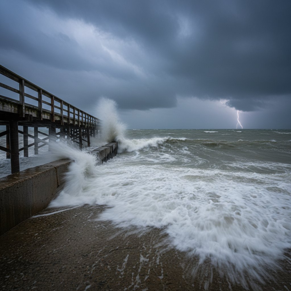
The NWS has issued Coastal Flood Watches for much of the Atlantic coastline north of Cape May. Erosion is also expected to be significant, as large waves pounded the shorelines for several tide cycles.
Actionable Steps for Residents
Public safety officials emphasize that preparation should be completed by Saturday evening. Key recommendations include:
- Verify Emergency Kits: Ensure you have flashlights, batteries, a first-aid kit, and a battery-powered radio.
- Communication Plans: Charge all mobile devices and backup batteries. Establish a check-in plan with family members.
- Home Safety: Clear storm drains near your property to prevent localized flooding when the snow eventually melts.
- Pet Safety: Bring all pets indoors and ensure they have adequate food and warmth.
As the storm develops, residents are encouraged to monitor local radar and NWS updates, as a shift of just 20 miles in the storm’s track could significantly alter snowfall totals and impacts.