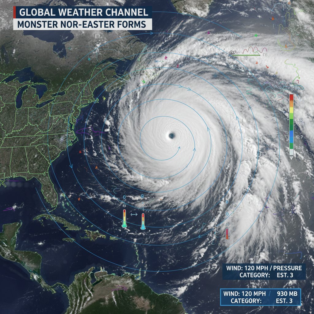
A meteorological phenomenon known as a "bomb cyclone" has officially made landfall and is tracking aggressively up the Eastern Seaboard today, February 1, 2026. The storm, which underwent rapid intensification over the Atlantic late Friday, has plunged twelve major metropolitan areas into a state of emergency. From the suburbs of Atlanta to the coastal reaches of Maine, federal and state agencies are warning residents that the peak of the system's impact is currently underway.
The National Weather Service (NWS) confirmed this morning that the central pressure of the storm dropped by more than 24 millibars in less than 24 hours—a process called bombogenesis. This rapid strengthening has transformed a standard winter system into a massive Nor’easter capable of producing hurricane-force wind gusts and snowfall rates exceeding three inches per hour in some corridors.
The Twelve Cities in the Crosshairs
The trajectory of the storm has placed a specific burden on the I-95 corridor. Forecasters have identified twelve major cities that are bearing the brunt of the system: Raleigh, Richmond, Washington D.C., Baltimore, Philadelphia, Newark, New York City, Hartford, New Haven, Providence, Boston, and Portland.
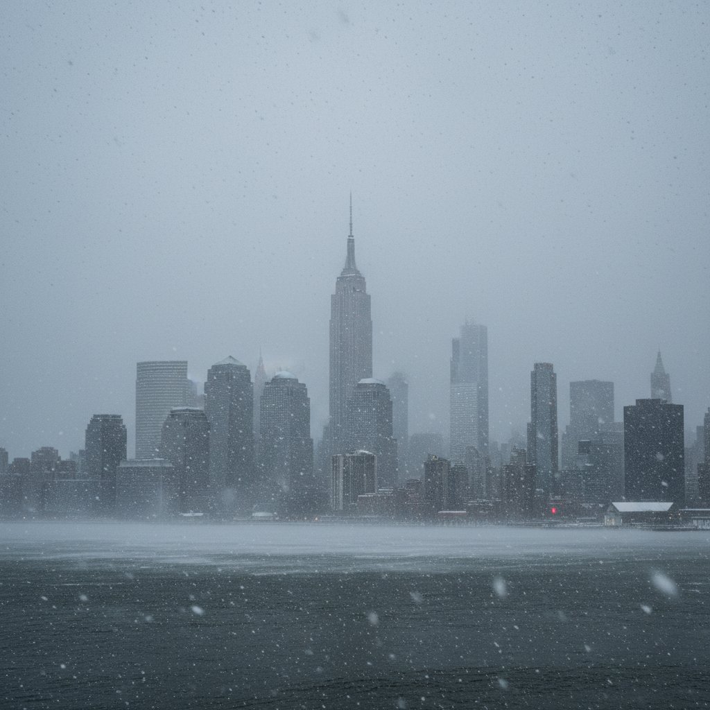
In Washington D.C. and Baltimore, the transition from a freezing rain mixture to heavy, wet snow occurred during the early morning hours, leading to dozens of jackknifed semi-trucks on the Capital Beltway. Further north, Philadelphia and New York City are reporting visibility of less than a quarter-mile as "whiteout" conditions take hold.

Infrastructure and Power Grid Strain
The human and economic impact of the storm is already becoming clear. According to PowerOutage.us, over 450,000 customers have lost electricity as of 8:00 AM ET, with the heaviest concentrations in Virginia and New Jersey. Utility companies have warned that restoration efforts will be significantly delayed until wind speeds drop below 35 miles per hour, the safety threshold for bucket truck operations.
The Federal Aviation Administration (FAA) has issued ground stops at several major hubs, including Reagan National, Philadelphia International, and JFK. More than 4,200 flights have been canceled nationwide, leaving thousands of travelers stranded. Amtrak has also suspended its Acela and Northeast Regional services between Washington and Boston through at least Sunday evening.
Coastal Flooding and Surge Concerns
While the inland story is dominated by snow, coastal communities are facing a different threat. The NWS has issued Coastal Flood Warnings from the Delmarva Peninsula to Cape Cod. The combination of the storm’s low pressure and high-velocity onshore winds is pushing a significant storm surge into bays and inlets.
In Scituate, Massachusetts, and Atlantic City, New Jersey, local law enforcement has reported that several coastal roads have become impassable due to seawater inundation. The flooding is compounded by the astronomical high tides associated with the lunar cycle, raising fears of significant property damage to beachfront residences.

Expert Analysis and Public Safety
Meteorologists emphasize that the "wrap-around" moisture from this system is what makes it particularly dangerous. Dr. Elena Vargas, a senior researcher at the National Center for Atmospheric Research, noted that the storm is drawing energy from unseasonably warm Atlantic waters, which provides the fuel necessary for such extreme precipitation levels.
"What we are seeing is a classic Nor'easter on steroids," Dr. Vargas explained. "The temperature gradient between the cold continental air and the warm Gulf Stream has created a vacuum effect, pulling the storm tighter and increasing wind speeds to levels usually reserved for tropical systems."
The Federal Emergency Management Agency (FEMA) has urged residents in the affected cities to remain indoors. "This is a stay-at-home event," said a FEMA spokesperson during a morning briefing. "The combination of extreme cold and zero visibility makes any travel a life-threatening risk."

Understanding the Bomb Cyclone
For those unfamiliar with the terminology, a bomb cyclone is essentially a mid-latitude storm that intensifies with extreme speed. While they are not uncommon in the North Atlantic, the current system's proximity to the coastline is what has triggered such widespread disruption.
| City | Expected Snow (Inches) | Peak Wind Gusts (MPH) |
|---|---|---|
| Washington D.C. | 6-10 | 45 |
| Philadelphia | 10-14 | 55 |
| New York City | 12-18 | 60 |
| Boston | 18-24 | 75 |
As the storm continues its northeasterly track, conditions are expected to deteriorate in Maine and New Brunswick through the overnight hours. Recovery efforts are slated to begin on Monday, though sub-zero wind chills are expected to persist well into the work week, hampering cleanup and power restoration.